
Jacaranda Journey


From La Paz, we took a bus and train to Tupiza where we began our 4 day Salar excursion. We ended the trip in Uyuni and took a bus to Potosi and Sucre afterwards.

Viewed from space, with Salar de Coipasa in the top left corner

Chuck sits on one of the cactus covered "islands" looking out at the sea of white salt

Hexagonal tiles of salt in an endless expanse; here in the dry season

The dramatic light on the hexagonal honeycomb of salt with our shadows at sunrise on the salt flats.


Rainy season is the opportunity for surreal mirror-like imagery.

Mirror-like images in the rainy season when a thin layer of water covers the salt surface.

The salar is composed of a salt surface crust several meters thick overlying brine saturated sediments (visible as small pools - the Ojos).

Miners from the town of Colchani create these salt pyramids to dry the salt before processing it.

Salt collected from piles on the Salar are dried futher in furnaces and then processed and bagged for sale

A kick-ass trip to Bolivia's Salt Flats

Without a distance perspective, fun illusionary photos are de rigueur for tourists

Modesta, our cholita cook, poses while we "walk" on her braids. She's probably done this a million times - on every trip for her clients. Think she enjoys it?

Street art image of their famous carnival with wild costumes and masks


Ornate bodice of a traditional Carnaval costume

We went to the cemetery on the Day of the Dead, Nov. 1, to see how Bolivian families honor their ancestors

Roberto O., the owner of La Torre Tours, showing us his family shrine to his grandparents in the kitchen.

Chuck boarding the train - the better transportation alternative since the bus travels on unpaved roads.


Departing Tupiza. Chuck and our driver/guide Roberto with our packed Toyota Landrover

Tupiza sits in the badlands where Butch Cassidy and the Sundance Kid met their fate, having chosen the wrong Bolivian to rob

Llamas are decorated with colorful bits of string to mark ownership, much like branding for cattle. Photo by Chuck on our ipad
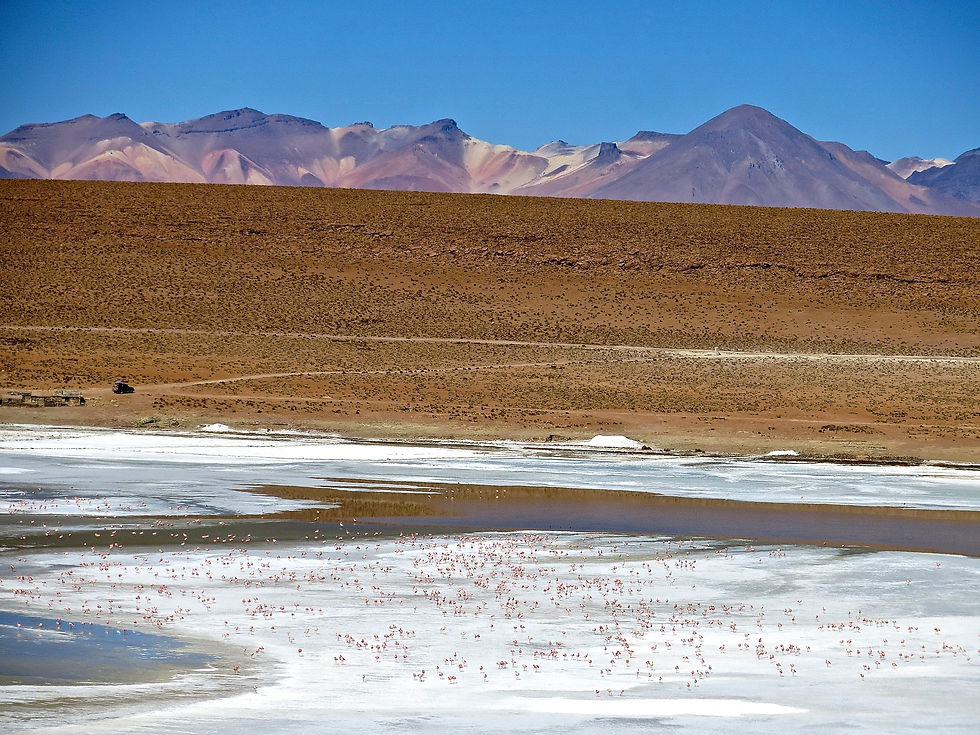
The Altiplano is home to three species of flamingos. Forget about those images of these beautiful pink birds under a palm tree in the tropics!

You can get close to them at rusty red Lago Colorado

There are three species of flamingos here - James, Andean, and Chilean

Pink color comes from the carotenoids in the crustaceans they eat

A lone Andean Fox. Zorro means "fox" in spanish

Licancabur volcano (5916 m.a.s.l.) in the background. The color is due to arsenic and other minerals; the hue shifts from turquoise to emerald green as wind shifts sediments

Sol de Mañana - a 4850m-high geyser basin with bubbling mud pots, fumaroles and the smell of sulfur fumes.

At Sol de Mañana geyser basin

Desert with surreal scattered rocks

This was the view from our remote hotel in the desert - the highest place we slept at an altitude of 4200 meters. The "roads" are just deep sandy tracks in the desert.

A cave sacred to the locals with a pre-Incan cemetery containing small chullpas.

Beautiful camouflage


The center of the Salar contains a few "islands", the remains of the tops of ancient volcanoes submerged during the era of prehistoric Lake Minchin.

Isla Incahuasi has a cactus forest of ancient origin

After sunrise on the Salt Flats and a hike on the cactus-covered "island", Modesta surprised us by with a heart cake for our last breakfast.

96 degree water at 13,000 foot altitude with chilling winds is a nice relief from the cold. We were there early before it got very crowded.

Ruinas de San Antonio where prospectors used slave labor.

Ruinas de San Antonio where prospectors used slave labor. Legend says the town was abandoned because there was either a slave rebellion, an epidemic, or men started to go blind / missing.

Our cholita cook, Modesta, whipped up some great meals from the back of the car.


Spectacular rust red water.

Chuck, Modesta, and Roberto
